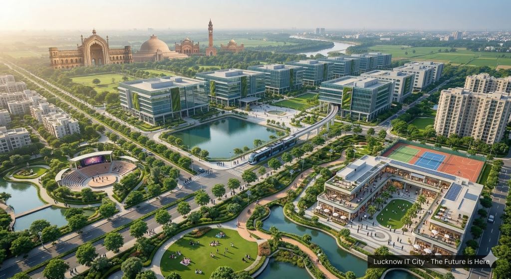
IT City: The Digital Nerve Center
Originally conceptualized as a 100-acre SEZ (Special Economic Zone), the project has evolved into a massive 2,660-acre integrated township by early 2026. It is designed around the "Walk to Work" philosophy, reducing urban sprawl and commute times. IT City, is the engine powering the city’s digital economy. In 2026, the two projects function as a symbiotic "Twin City" model on the Sultanpur Road corridor.
As of 2026, the IT City project (also referred to as the "New IT City" or "IT City Township") has expanded significantly beyond its original scope. According to the latest data from the Lucknow Development Authority (LDA), here is the detailed breakdown of the villages involved and the total area.
Key Infrastructure Pillars:
- The AI City Hub: A dedicated zone for Artificial Intelligence research and data centers, aimed at positioning Lucknow among the top 20 global AI hubs.
- The Talent Pipeline: Anchored by IIIT Lucknow and the HCL training center, which collectively churn out thousands of industry-ready graduates annually.
- Enterprise Zones: 350+ acres reserved strictly for IT/ITeS companies, global business parks, and startup incubation centers.
2. Data & Analytics: The Economic Impact
The scale of IT City in 2026 represents a significant shift in Uttar Pradesh’s GDP contribution from the service sector.
| Metric | 2024 Status | 2026 Analytics (Current) |
|---|---|---|
| Job Generation | 5,000 (Direct) | 25,000+ (Projected) |
| Commercial Occupancy | 60% | 92% (Phase 1) |
| Residential Units | Minimal | 10,000+ Plots/Flats launched |
| Connectivity Index | Shaheed Path Only | Kisan Path + Metro Phase 2 linkage |
Sponcered Link : LDA Approved Plots In Integrated Township At Sultanpur Road Lucknow
3. Why 2026 is the "Entry Year"
The Lucknow Development Authority (LDA) has officially launched the Land Pooling Model for IT City in early 2026. This model has successfully secured 90% of the land without litigation, ensuring:
- Clear Titles: No risk of farmer disputes.
- Infrastructure Lead: Roads and sewage lines are being laid before residential possession.
- Connectivity: The new 2-km feeder road now connects the heart of IT City directly to the Kisan Path (Outer Ring Road), making the airport a 20-minute drive.
4. Strategic Outlook
Lucknow is no longer just a "B-tier" backup to Noida. With the UP Data Centre Policy 2025-26 providing heavy subsidies, IT City has become a preferred destination for:
- Tier-4 Data Centers (due to stable land and power).
- Back-office operations for FinTech firms moving away from high-cost Bengaluru/Mumbai.
- AI Startups leveraging the proximity to IIIT-Lucknow.
6. Total Area & Layout
The total planned area for the IT City project on Sultanpur Road/Kisan Path is approximately 2,858 acres. While the initial phase focused on a smaller SEZ, the 2026 expansion encompasses a massive integrated township divided into 10 sectors.
- Industrial/IT Zone: 445 acres
- Commercial Zone: 260 acres
- Residential Zone: 10,000 plots (ranging from 72 sq. m to 200 sq. m)
- Green Belt & Golf City: 200 acres
- Water Body/Ecological Zone: 15 acres
Sponcered Link : LDA Approved Plots In Integrated Township At Sultanpur Road Lucknow
7. List of Villages Under IT City
The land for this mega-project has been pooled from 11 key villages located in the Mohanlalganj Tehsil. These villages are strategically positioned between the Sultanpur National Highway and the Kisan Path (Outer Ring Road).
| Village Name | Significance in the Project |
|---|---|
| Bakkas | One of the primary hubs for residential sector development. |
| Mohari Khurd | Location of the first LDA site office and the start of grid road construction. |
| Bhatwara | Significant contributor to the industrial and IT/ITeS zones |
| Sikandarpur Amoliya | Central to the grid road network connecting to Kisan Path. |
| Sonai Kanjehra | Part of the core land pooling area for mixed-use development. |
| Siddhpura | Earmarked for social infrastructure and educational zones. |
| Parehta | Focus on green belts and residential plotting. |
| Pahadnagar Tikaria | Strategic location for connectivity between the two highways. |
| Rakibabad | Part of the outer sector planning (Sectors 15–18). |
| Khujauli | Area designated for future expansion and commercial buffers. |
| Mastemau | Highly active in the land-pooling model; houses key residential sectors. |
8. Land Pooling Update (March 2026)
The project is being developed using a Land Pooling Model, which has avoided the traditional delays of forced acquisition.
- The 25% Rule: Landowners who contributed their fields receive 25% of the land back as fully developed residential or commercial plots within the township.
- Allotment Status: As of March 12, 2026, the LDA has already completed the lottery for 549 developed plots (Sectors 15, 16, 17, 18, and 30) for the initial 350+ farmers who pooled their land.
Investor Tip: The development of the first Grid Road system (45m and 30m wide roads) in Mohari Khurd and Bakkas has already led to a surge in property inquiries in these specific village boundaries.
Sponcered Link : LDA Approved Plots In Integrated Township At Sultanpur Road Lucknow
9. Recent Development Update (March 2026)
- Relocation: The LDA has officially started the registry for shops in the Medicine Market (Mandi) within the Wellness City boundary, aimed at moving the wholesale trade out of the congested Aminabad area.
- Land Pooling Success: In the village of Mastemau, the LDA successfully signed agreements for 127 additional acres this quarter, offering farmers developed plots in return for their ancestral land.
- Price Insight: Agricultural land in these villages, which was valued at ₹1.35 Cr per Bigha in late 2024, has now touched ₹1.85 Cr – ₹2.10 Cr per Bigha in early 2026 due to the visible road constructio.
Investment Outlook
With the current 25% annual growth, experts predict that if the Metro Phase 2 extension towards Sultanpur Road is finalized by late 2026, the residential rates in Wellness City could potentially cross the ₹7,500 per sq. ft. mark by 2028, rivaling the prime areas of Gomti Nagar.
.jpg)
Keywords : LDA Township Lucknow, Residential Plots In IT City Lucknow, IT City Sector Map, IT City Lucknow Location, Smart City Lucknow, Lucknow Real Estate Investment, Property Near IT City Lucknow, IT Hub Lucknow, Commercial Property In IT City, IT City Project Lucknow, Land Pooling Scheme Lucknow, Best Investment Location In Lucknow, Future Development In Lucknow, Property Near Kisan Path, Plots Near HCL Lucknow, Integrated Township Lucknow

Leave a Comment